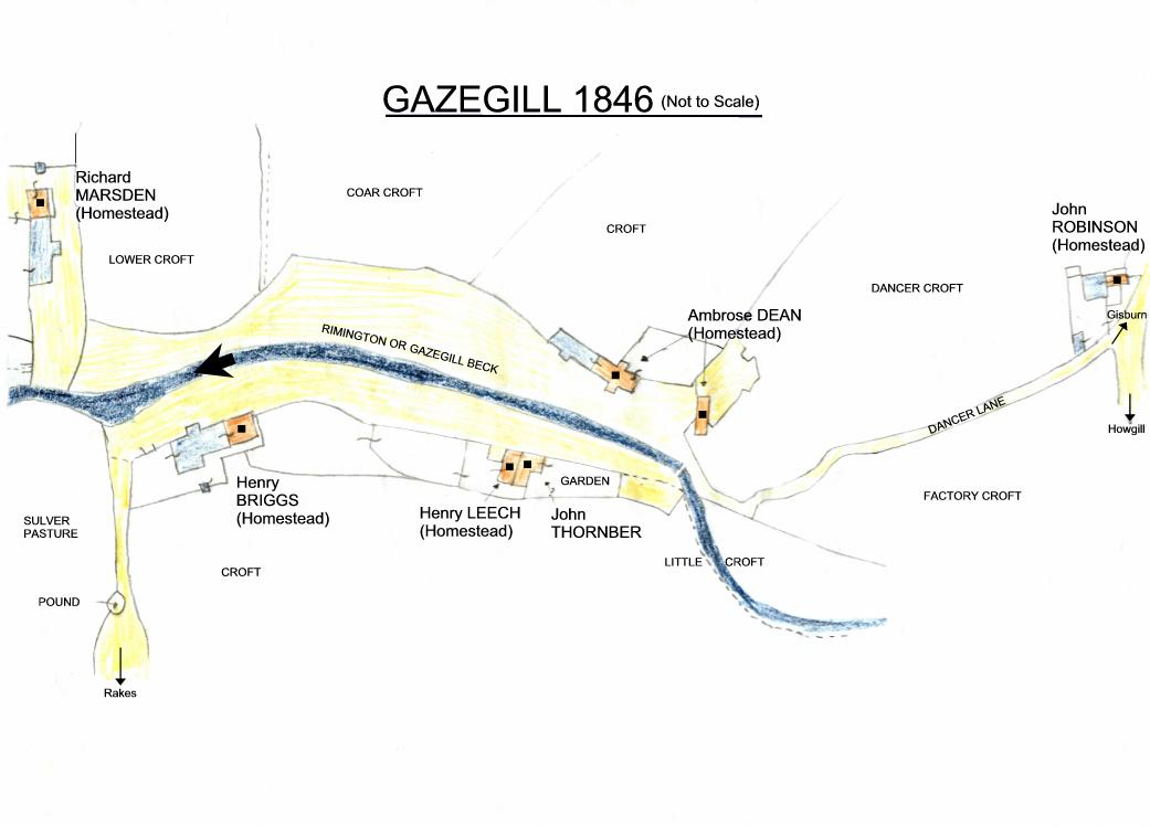
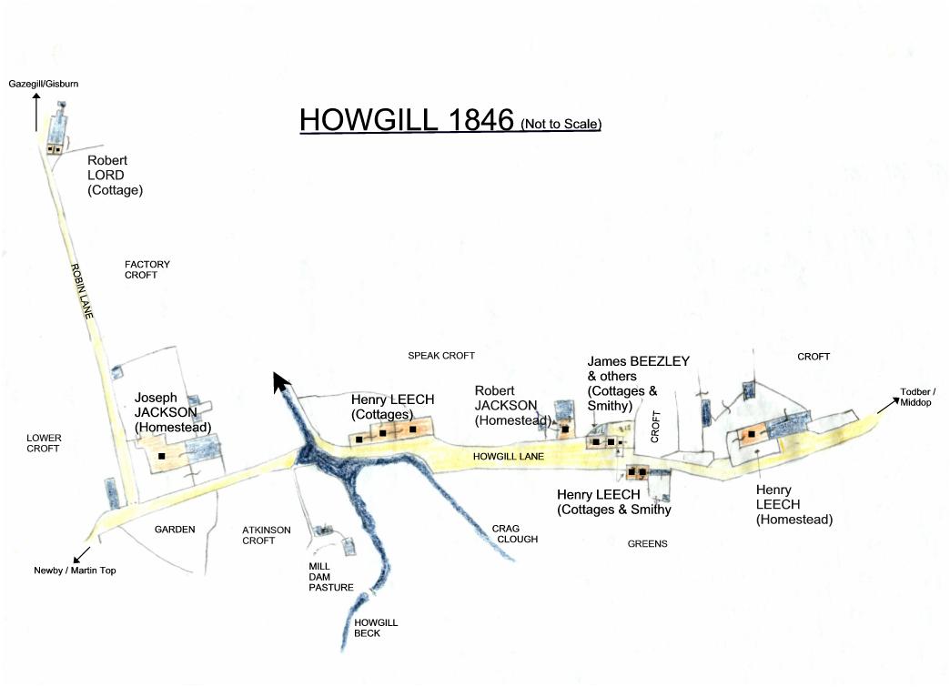
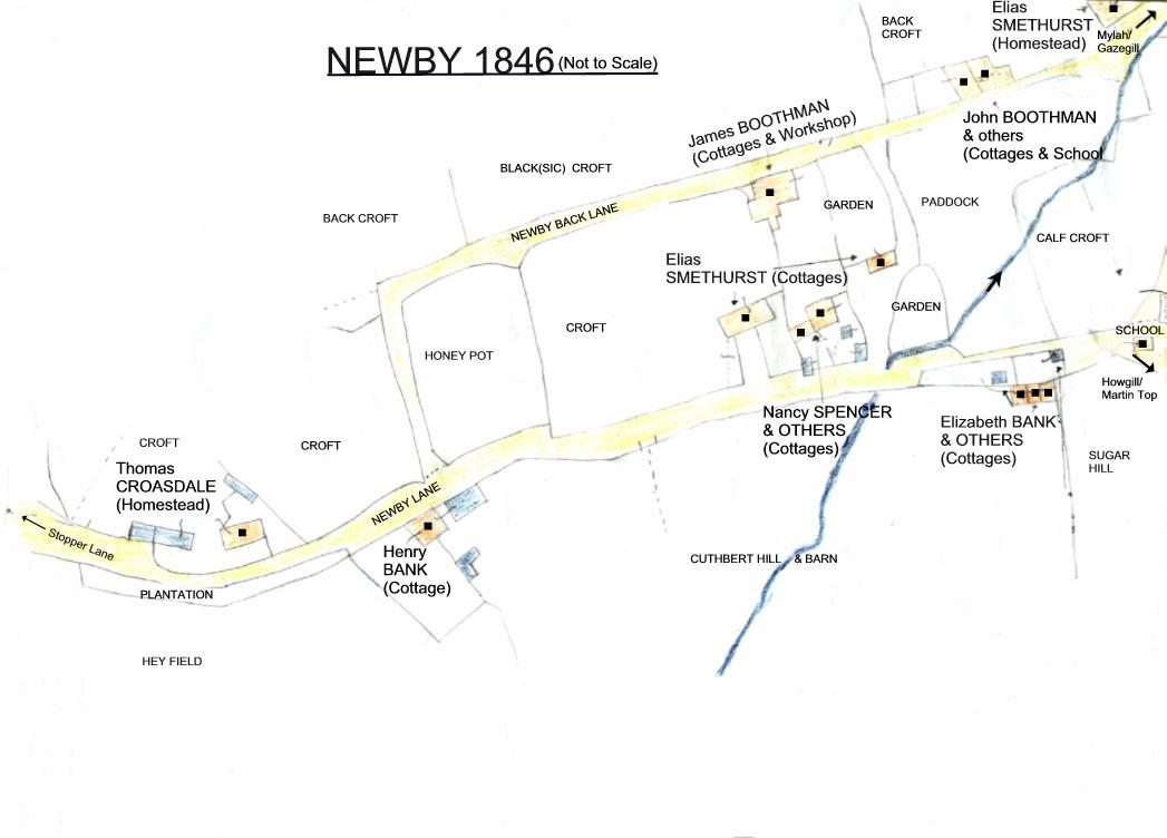
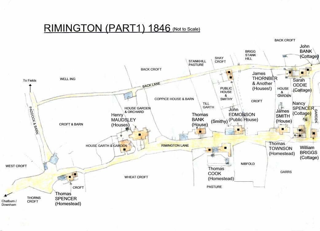
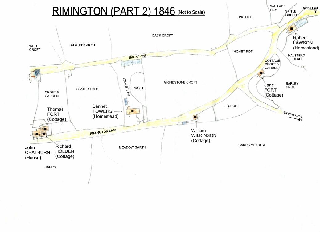
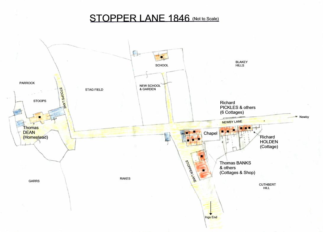
The information presented here is taken from Gisburn Church's original copy of Rimington Township tithe award drawn up in 1846. It was one of three, the other two going to the Diocese archives and the Tithe Commission, London (received 1848). The award consists of a plan of the township and a schedule. The plan identifies all the properties, fields, becks and roads, (also tracks and footpaths) allocating each a plot number. The schedule lists the landowners, occupiers and the plot numbers. For each number there is a name description of it and its state of cultivation where applicable and the rent charge payable.
All the awards were drawn up to end the payment in kind method to the Established Church: the tenth cow, sheep, sheaf of corn, etc. which had gained increased opposition with the growth of Nonconformity, and a rent charge was levied instead. (Quakers had already refused to pay tithes to any owner.) Rent charges disappeared in England by 1936.
The church's copy of Rimington's tithe award was found in the attic of an architect's office in the 1970s in Clitheroe when he was clearing it out because he was moving away. He, Gordon Heap of Mosna, was a friend of the family and thought we might like to have it – none of us knowing the significance of the document at the time.
We kept it in a large plastic bag behind the settee for many years and lent it out occasionally. The last time was when it was returned with a brew cup ring stain on the map. This prompted me to trace the plan and transcribe the schedule for fear of it being damaged further. It is now held at the Lancashire County Record Office, Preston.
So how did the document come to be in the Clitheroe attic in the first place? I suspect it was borrowed from the church in 1927 after the last Lord Ribblesdale died. There was going to be a substantial debt to be paid in death duties. I believe the estate's solicitors, Robinson & Sons, Clitheroe, were instructed to gather information about Lord Ribblesdale's current tenants and holdings in Rimington and used the document as a guide. When it was done with it was put to one side and eventually ended up in the attic out of the way and forgotten about.
A portion of the Gisburne Park Estate was sold Wednesday, May 4th 1927 at the Old Vicarage Pavilion, Gisburn. The Rimington properties included were Great Todber, Little Todber, Bonny Blacks, New Ings and Watt Close.
The information regarding Middop's tithe award came via another route. Sometime in the early 1990s the then Vicar of Gisburn, the Reverend Jonathan Lumby, staged a Maps Exhibition one weekend inside the church, it still then having all the other township awards belonging the parish: Gisburn, Paythorne, Swinden, Newsholme, Gisburn Forest, Nappa and Middop. All the tithe awards were traced and transcribed (bar Nappa's which was too fragile to be handled.) Middop's information comes from that project. All these original documents are also now at Lancashire Archives (previously Lancashire Record Office) at Preston.
Rimington's tithe schedule is presented here as a spreadsheet. The individual properties were not titled like Middop's were but I have titled them in brackets. I have also noted where more recent properties have been built on the plots, and barn conversions. There are also two indexes – names and places. There are no indexes for the Middop one because it is a much shorter schedule.
Brian Stott 2020
To download an Excel spreadsheet of the 1648 Hay Tithes click here
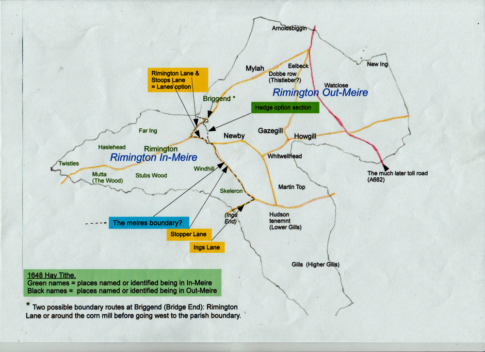
Following further investigations Brian Stott has found information about about early Rimington 'meares' or boundaries.
To read about these meares click here
Map of Rimington meares
Middop Tithe Schedule 1847 (Open Office Document)
Rimington Tithe Schedule 1846 (Open Office Document)
Rimington Tithe Award Maps Google KML files these show the field names and the landuse recorded in the 1846 award.
To add to your Google Earth Pro, download the files, in Google Earth go to File then Open browse for the downloaded files and then Open.
Field Names rimington-tithe-field-names.kml
Field Numbers rimington-tithe-field-numbers.kml
Arable rimington-tithe-arable.kml
Arable and Pasture rimington-tithe-arable-and-pasture.kml
Meadow rimington-tithe-meadow.kml
Pasture rimington-tithe-pasture.kml
Woodland and Plantation rimington-tithe-woodland.kml
Homesteads rimington-tithe-homestead.kml
Mines rimington-tithe-mines.kml
Lanes and Roads rimington-tithe-lanes-and-roads.kml
Landuse not listed rimington-tithe-not-listed.kml
1781 Land Tax (Open Office Document)
Note Open Office Documents Can be opened by MS Office.